Aims

The automatic supply of the NDVI (Normalized Difference Vegetation Index) and EVI (Enhanced Vegetation Index) images provides information on the plant cover and enables us to monitor the time course of the ecosystems on Sierra Nevada for a time series that begins in the year 2000.

Method and effort

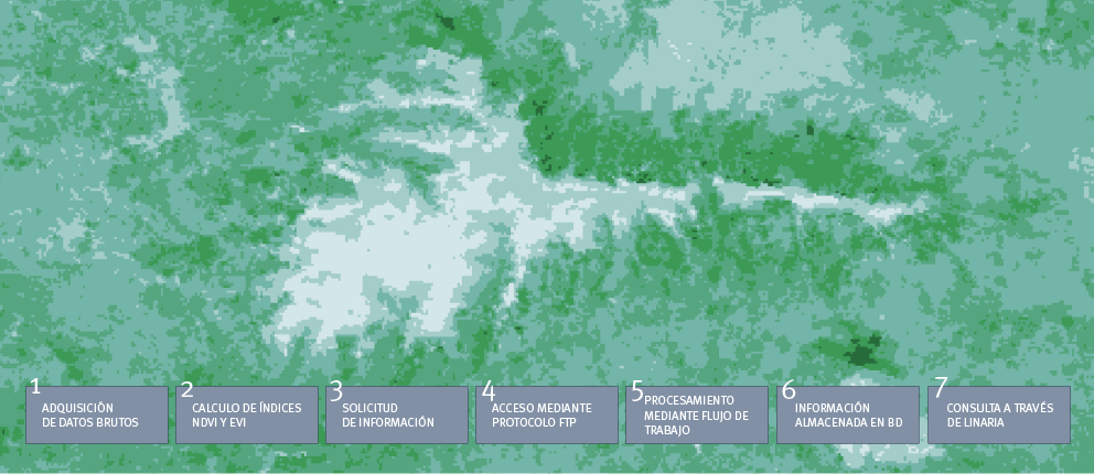
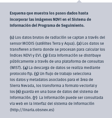
The NDVI and the EVI are calculated as the quotient between the part of the incident radiation absorbed by the vegetation (in the visible red spectrum) with respect to the quantity of radiation reflected by the surface (in the near-infrared spectrum). The EVI improves the sensitivity with respect to the NDVI to detect the vegetation whether thin or dense. The NDVI and EVI images are generated by the MODIS sensor, lodged in the NASA satellites Terra and Aqua. Both vegetation indices provide an idea of the photosynthetic capacity of green plants. They are, therefore, proxies of the primary production of ecosystems.

Periodicity

The NDVI and EVI images are created by MODIS sensor every 16 days. The image-processing system permits them to be automatically introduced into the information system periodically each time that a new image is created.

Results

Download PDF: Español / English

References

Huete, A.R., Justice C. y van Leeuwen, W. 1999. MODIS Vegetation Index (MOD 13), EOS MODIS Algorithm-Theoretical Basis. Document, Version 3. NASA Goddard Space Flight Center. 120 pp.
Huete, A., Didan, K., Miura, T., Rodríguez, E.P., Gao, X. y Ferreira, L.G. 2002. Overview of the radiometric and biophysical performance of the MODIS vegetation indices. Remote Sens. Environ., 83: 195-213.

en_USEN