The Ensenada Cadastre (Catastro de Ensenada) was the preliminary step for a tax reform—which was never ultimately implemented—aimed at simplifying the complex provincial revenues of the time and replacing them with a Single Contribution "in proportion to what each person owns, with equity and justice." To determine the real income of individuals, localities, and provinces of the Kingdom, it was first necessary to conduct a universal "inquiry" (averiguación) of all assets held by subjects without exception, including the clergy and nobility. The Cadastre was compiled based on individual declarations from both family and institutional units. It consisted of: asset declarations by owners, verification of accuracy by the Administration with the help of experts and technicians, the creation of registry books, the calculation of the fiscal value of those assets, and the establishment of summary sheets for each town (separating lay and ecclesiastical records) and, in turn, each province. All of this served to calculate local, provincial, and royal income.
Methodology
The archives of the Marquis of Ensenada’s Cadastre for the various municipalities in the province of Granada are held at the Provincial Historical Archive. Digitized documents from the 1752 cadastre for the districts of Cáñar and Barjas (which are currently merged into the single municipality of Cáñar) were acquired.
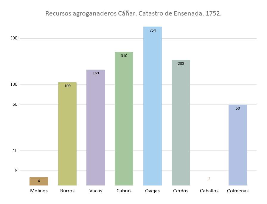
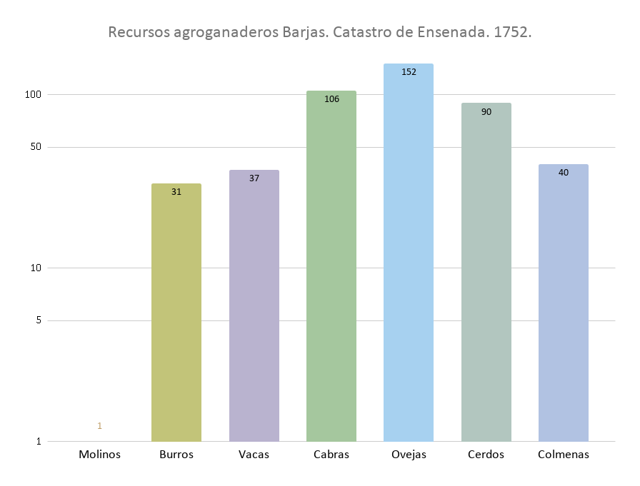
These consist of a total of 1,296 pages containing answers to the general questions of the cadastre. For each landowner in these districts, the documents detail the number of estates (fincas) owned, the crops or vegetation present, the surface area, and the approximate location. Each estate is located by naming the pago (traditional land division) in which it sits and its adjacent plots. Some of the recovered information, such as the amount of livestock and the number of mills, could not be assigned a spatial component and is presented in graphic form instead.
Subsequently, exhaustive work was carried out to extract information that could be mapped. This began with the creation of a database to store the alphanumeric data of each owner and their estates, grouped by the various pagos.
The next step was to identify the location of the pagos where the estates were situated to provide the information extracted from the cadastre with a spatial component.
In doing so, several scenarios emerged:
- Some current pagos coincide exactly with those existing in 1752.
- Some pagos from 1752 are now contained within current ones.
- Other 18th-century pagos have disappeared from modern cartography.
To organize the historical pagos and link them to modern ones, the following protocol was used:
- Digitization of current pagos based on modern cadastral information.
- Expert consultation to analyze historical information and link it to currently available data (involving technicians and the president of the local Irrigation Community).
- Participatory mapping workshops with a group of elderly farmers, livestock breeders, and woodcutters from the study area to resolve any remaining uncertainties. taller de cartografía participativa a grupo de agricultores, ganaderos y leñadores ancianos de la zona de estudio.
The results of this work can be consulted in the following map. Click on the different pagos to view the associated information.