The Sierra Nevada Global Change Observatory is an institutional collaboration project between the Regional Ministry of Sustainability and the Environment of the Regional Government of Andalusia and the University of Granada, aimed at jointly developing a long-term ecological monitoring programme, as well as managing and enhancing the value of the information obtained.
1. OBJECTIVE AND WORK METHODOLOGY AT OBSNEV
The main objective is to diagnose the degree of exposure of Sierra Nevada ecosystems to the impacts of global change, promoting ecosystem resilience and adaptation, and to transfer scientific knowledge to management bodies and to society in general. The steps followed in this work are:
1.1 Data collection
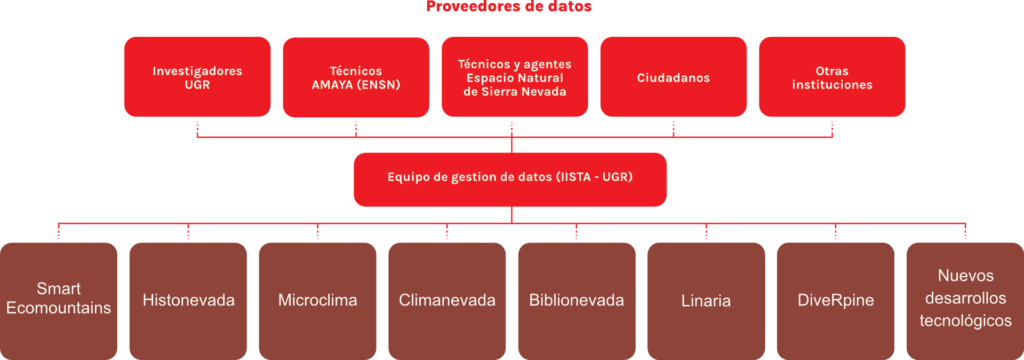
The information is derived from field data and remote observations (satellites). A series of monitoring protocols has been established under the scientific supervision of the University of Granada (UGR). Field data collection is carried out by technicians from the Environment and Water Agency and by environmental officers from the Sierra Nevada Natural Park. In addition to these protocols, the Observatory compiles information gathered over the past decades by scientists from the University of Granada and other research institutions in the Sierra Nevada. Translated with DeepL.com (free version)
These highly heterogeneous datasets make it possible to monitor the health status of Sierra Nevada ecosystems and biodiversity in a global change context.
1.2 Documentation and organisation
All the information collected must go through a process of validation, documentation and harmonisation in order to be integrated and published in open-access databases and repositories.
1.3 Analysis within a scientific framework
This analysis, carried out by experts in each thematic area at the University of Granada, adds value by generating applications and services that facilitate the use of data by different user profiles to whom these services are addressed (scientists, managers and citizens).
1.4 Transfer of scientific knowledge to management
Applications such as Linaria, ClimaNevada, BiblioNevada, DiveRpine or HistoNevada are designed to effectively collect and integrate information across different thematic areas in order to transfer it to environmental management.
1.5 Citizen participation
In addition to researchers from the University of Granada and staff from the Regional Ministry, citizen science is becoming increasingly relevant as a means of involving society in the process of generating data useful for science and management. Citizen science activities enable public participation in the collection of field data, the contribution of technical or graphic documents, or the development of participatory governance projects. Citizen participation is becoming increasingly important in areas as diverse as the monitoring and management of aquatic systems, climate, historical reconstruction of human use of Sierra Nevada, maintenance of traditional irrigation channels (acequias de careo), pasture and forest management, conservation of fauna and flora species, or detection of invasive species.
Similarly, the incorporation of public and private entities through collaboration agreements with the University of Granada is also becoming increasingly important for the collection of climate data or historical information in Sierra Nevada (see Figure 1).
In short, OBSNEV:
- Enhances, documents, integrates and reuses information on biodiversity and global change in Sierra Nevada,
- Analyses this information within a scientific framework,
- Transfers the most up-to-date scientific knowledge to environmental decision-making through the development of adaptive management projects,
- Establishes and consolidates permanent spaces for collaboration between researchers and environmental managers,
- Incorporates the use of new information and communication technologies into research and field monitoring, adaptive management projects and database management
- Increases scientific culture and citizen participation.
2. FIRST STAGE OF OBSNEV
On the time axis in Figure 2, the beginning of the Observatory (year 2008) is shown, associated with the Andalusian Global Change Observatory Network. This initiative is funded by the Regional Ministry of the Environment and implemented by its public company AMAYA. The Spanish National Parks Agency and the Biodiversity Foundation fund the installation and maintenance of several meteorological stations in Sierra Nevada, also contributing to the financing of some activities linked to the monitoring programme. Scientific coordination for the launch and scientific supervision of the monitoring programme and the development of the information system is provided by Prof. Regino Zamora (University of Granada), through an annual earmarked grant of €73,000 funded by the Regional Ministry to the University of Granada. Between 2015 and 2018, this funding was interrupted; however, from the scientific coordination side, work continued to keep the academic support of the Observatory’s activities alive, mainly thanks to European projects in which we participated (EUBON, LTER, ECOPOTENTIAL, LIFE-ADAPTAMED), as well as projects obtained through calls for Scientific Infrastructures from the Ministry of Science and Innovation (MICIN) and the Spanish Foundation for Science and Technology (FECYT). For its part, the Regional Ministry’s public company (AMAYA), together with the technicians and environmental officers of the Sierra Nevada Natural Area, maintained during that period and up to the present day a large part of the field monitoring programmes initiated in 2008, adjusted to budgetary constraints.
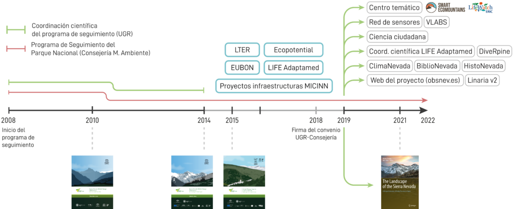
The most relevant achievements of the first stage (2008–2014) are:
- Definition of the objectives to be addressed by the global change monitoring programme in Sierra Nevada, based on scientific questions aligned with the management needs of the National Park and with international standards.
- Design and implementation of the methodologies for Global Change monitoring in Sierra Nevada from 2008 onwards (monographs published in 2010 and 2014).
- Compilation of the first results obtained from the global change monitoring programme and of the information provided by the different research groups working in Sierra Nevada (monograph The Footprint of Global Change in Sierra Nevada (2015), followed by an English version (2016)
- Development of the first Linaria information system, Linaria 1 (2009–2014).
- Joint planning of the first adaptive management projects between the University of Granada and the Regional Ministry as a result of the collaborative framework created within the Observatory.
3. SECOND STAGE OF OBSNEV
The second stage began with the signing of the agreement in July 2018 between the University of Granada and the Regional Ministry of Agriculture, Livestock, Fisheries and Sustainable Development (implementation period: 2018–2022; total funding: €380,000). This agreement represents the institutional commitment of both the University of Granada and the Regional Ministry to a long-term joint project. Based on the positive results obtained, both institutions (UGR and the Regional Ministry) decided to extend the agreement for a further three years (2022–2024) with the same level of funding (€380,000). During this latest stage, the tasks initiated in 2008 have been maintained (scientific coordination of the monitoring programme and data collection carried out by AMAYA, management and documentation of information, incorporation of UGR researchers’ work as data providers, transfer to management and development of adaptive management projects, and national and international collaboration), while at the same time new activities have been deployed, which are described below:
3.1 New Website
The new web portal of the Sierra Nevada Global Change Observatory is structured at two levels: one oriented towards the general public and a restricted internal access for managers, technicians and scientists participating in OBSNEV. The public website presents the role of the Observatory in terms of research, global change monitoring by thematic areas, adaptive management, historical information and citizen participation in Sierra Nevada. It is also responsible for dissemination through a news channel providing the most relevant information as well as products and applications related to global change in Sierra Nevada. The restricted access area has been designed as a knowledge transfer tool between science and management within the Observatory framework. Some of its main functionalities include coordinating meetings between scientists and managers, drafting and storing minutes, providing support for requesting scientific advice and documenting responses, transferring monitoring protocol data between both groups, and managing outreach activities.
3.2 Linaria 2
Linaria is an information system for integrating data from the monitoring protocols of the Sierra Nevada Global Change Observatory. Data are entered through web forms specifically designed to meet the needs of each type of sampling and are inserted directly into a spatial PostgreSQL/PostGIS database. Linaria distinguishes between three user profiles with different functionalities and levels of access: observers, who are responsible for entering data into the system; protocol managers, who are responsible for data validation and the organisation of observers; and, finally, system administrators.
3.3 BiblioNevada
BIBLIONEVADA is an application for consulting the scientific output published in relation to biodiversity, the environment and ecological aspects derived from Global Change in Sierra Nevada between 1970 and 2025. Following searches conducted in the Web of Science and Scopusdatabases, complemented by systematic searches in other search engines and scientific journals from the 1970s to the 1990s, a total of 957 publications have been compiled. These records have been classified according to three criteria: (1) the scientific categories established by Web of Science, (2) the thematic areas of OBSNEV, and (3) traditional environmental categories.
3.4 HistoNevada
HISTONEVADA is a web application for the collection and consultation of historical images and documents related to biodiversity, landscape, the environment and the use of natural resources in Sierra Nevada. Designed as a citizen science tool, HISTONEVADA offers a simple and agile interface that allows users to contribute both images (photographs, drawings, illustrations, posters or engravings) and historical documents (books, articles, manuscripts, administrative documents, newspapers/magazines or cartography). The objective of HISTONEVADA is to recover historical information of great value for understanding the natural and human-driven changes that have occurred throughout the history of Sierra Nevada. The aim is to highlight and preserve historical information and knowledge that, if not collected and documented, is at risk of being lost.
3.5 ClimaNevada
CLIMANEVADA is a database of climatic information for Sierra Nevada, whose main objective is the harmonisation, standardisation, documentation and integration of existing climate data in the Sierra Nevada area, originating from a wide variety of sources. ClimaNevada documents all climate data in terms of location, station/sensor status, owner/maintenance manager, data status, validation, integration, etc. Likewise, ClimaNevada enables the traceability of climate records in Sierra Nevada, facilitating user access to the original data source. It also incorporates climate information from sensors installed in short-term projects, which would otherwise be difficult to access.
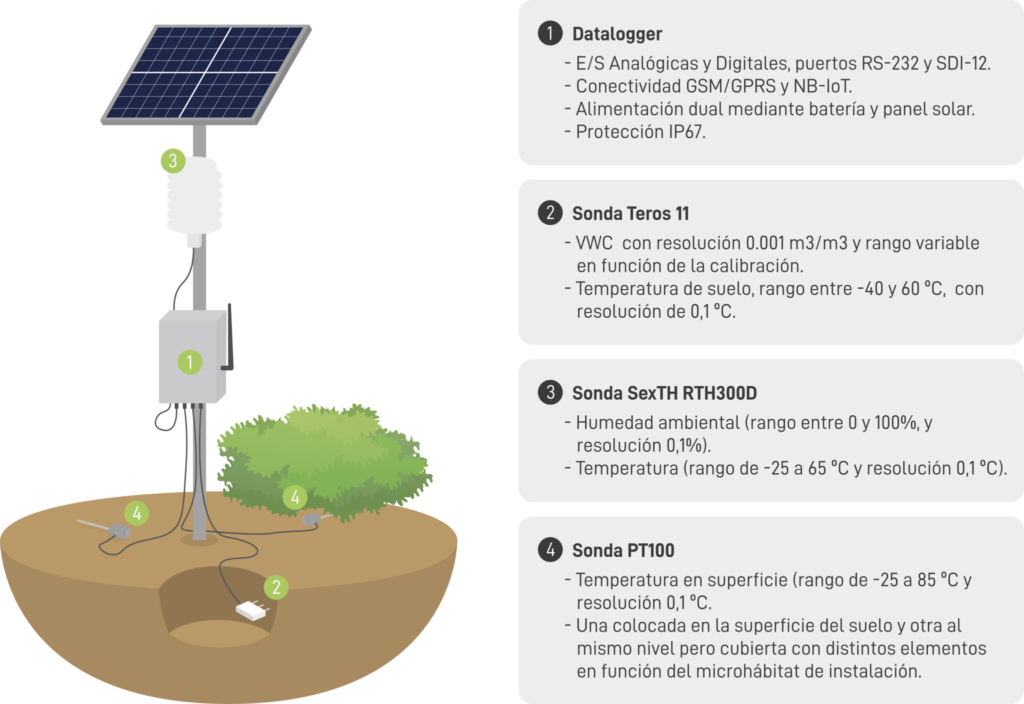
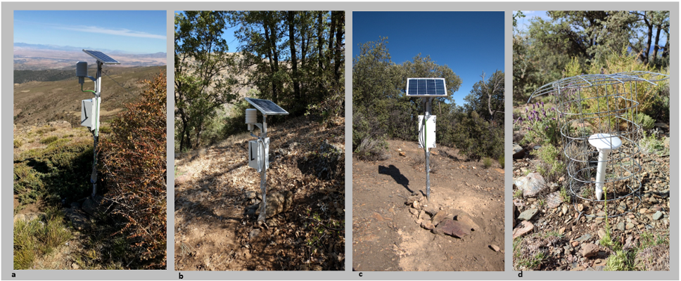
3.6 Sensor network: design, field deployment and visualisation
Los responsables del Espacio Natural necesitan información climática detallada para atender a sus tareas de gestión. Sin embargo, apenas hay información climática dentro del Espacio Natural de Sierra Nevada, aparte de la que se obtiene en la Estación de Esquí de Pradollano. Para paliar esta importante carencia de información, hemos designed and deployed state-of-the-art sensor networks with the aim of characterising the different microclimates found in a mountain range as heterogeneous as Sierra NevadaZamora et al. 2021). Thanks to this deployment, we are monitoring, at a very fine spatial resolution, variations in air and soil temperature and humidity along a broad altitudinal gradient in Sierra Nevada. The sensor network consists of a set of multiparametric microstations that integrate cutting-edge digital sensors and enable data transmission to servers. These devices operate indefinitely, with dual power supply via solar panel and battery. Measurements are taken every 30 minutes, and data transmission occurs every 6 hours.
So far, we have deployed 93 microstations across different Sierra Nevada ecosystems (oak forests, pine forests, holm oak woodlands, juniper scrublands and high-mountain broom shrublands, grasslands), along a wide altitudinal gradient (from 1,100 m to 2,400 m) and across different aspects.
Likewise, we have deployed 550 TOMST TMS4 microsensors across a large area of Sierra Nevada in the provinces of Granada and Almería, from 1,000 m to 3,000 m above sea level and in all aspects. These devices incorporate air and soil temperature and humidity sensors. This extensive deployment allows us to carry out field validation of satellite information obtained from remote sensors, at a spatial and temporal resolution unprecedented to date in Europe.
In addition to developing and installing our own equipment, we are direct collaborators with the European LifeWatch Infrastructure in the deployment and testing of new dataloggers developed by them, aimed at real-time monitoring and the integration of information into international data lakes. Currently, the University of Granada has an active collaboration agreement with LifeWatch-ERIC.
3.7 Integration of data from highly diverse sources
One of the major contributions of OBSNEV is bringing together data within the same thematic area that have been collected by very diverse sources, generating a common database. An example of this is the ClimaNevada application, which integrates data from more than 20 different networks or institutions. Another example is the dataset on aquatic insects in Sierra Nevada, a successful case of collaboration between management and research, as it integrates data from both domains and consists of:
- More than 1,700 surveys carried out from 1901 to 2022.
- More than 60 rivers sampled along an altitudinal gradient ranging from 800 to 3,040 m a.s.l.
- More than 180 taxa identified among over 203,000 individuals sampled.
3.8 Creation and maintenance of long-term data series
The Observatory has succeeded in generating the longest possible time series of data across different thematic areas: climate, aerosols, biodiversity, ecological processes in aquatic and terrestrial systems, historical and socioeconomic aspects, etc. These time series allow us to:
- identify persistent patterns in variables such as temperature, precipitation, CO2 exchange, or biodiversity loss;
- distinguish between natural variability (such as seasonal cycles) and anthropogenic changes (such as global warming);
- feed predictive models that project how climatic conditions may evolve in the future;
- in short, monitor the health status of Sierra Nevada ecosystems and biodiversity in a global change context.
Some examples of the importance of time series are shown below:
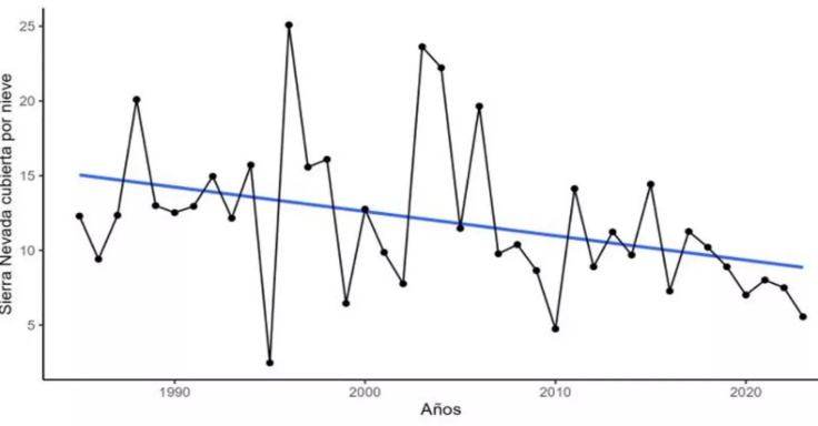
3.8.1 Evolution of snow cover
Based on satellite imagery, it has been possible to quantify temporal changes in the extent of snow cover over the last 40 years in Sierra Nevada.
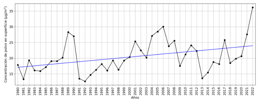
3.8.2 Saharan dust concentration
The following graph shows interannual variability over the last 40 years, revealing an increasing trend in dust concentration.
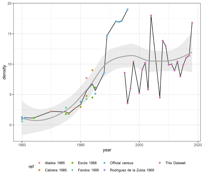
3.8.3 Long-term monitoring of the Iberian ibex population in Sierra Nevada
This dataset provides long-term information on the presence of the Iberian ibex (Capra pyrenaica hispanica) in Sierra Nevada, as a result of annual surveys conducted from 1993 to 2018 by the technical staff of the Sierra Nevada National Park.
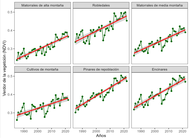
3.8.4 Changes in vegetation productivity
In recent decades, increased vegetation growth has been observed in Sierra Nevada due to the abandonment of logging activities and climate change, especially at mid and high elevations. The current rise in temperatures allows woody vegetation (oak forests, pine forests, juniper scrublands, broom shrublands, etc.) to grow more and for more months at all altitudinal levels, acting as an important CO₂ sink.
3.9 Adaptive management projects. LIFE ADAPTAMED project
The scientific knowledge generated in Sierra Nevada has made it possible to validate both traditional and new management techniques under environmental scenarios derived from global change, through the development of projects aimed at promoting ecosystem resilience and adaptive capacity. All this previous experience served as the basis for the development of the ambitious LIFE-Adaptamed governance project, led by the Regional Ministry of the Environment of the Regional Government of Andalusia. The project focused on the implementation, monitoring, evaluation and dissemination of adaptive management measures in different ecosystems across Andalusia.
3.10 Decision-making support tools: Diverpine (https://ajpelu.github.io/diveRpine/)
The scientific information we have obtained on the functioning of forest systems has enabled us to develop diveRpine (Diversification of pine plantations), a decision-support tool that simulates the dynamics of forest ecological processes associated with the naturalisation of pine plantations. The resulting simulations help managers identify which pine plantations are most in need of intervention (active restoration), as opposed to other stands where intervention is unnecessary (passive restoration), depending on the ecosystem services that managers wish to enhance.
3.11 Virtual Laboratories
En el OBSNEV hemos identificado tres líneas de desarrollo para el desarrollo de laboratorios virtuales, que son fácilmente extrapolables a otras montañas: Clima, Ecosistemas y Especies. Estos Laboratorios Virtuales adoptan un enfoque multidimensional compuesto por las capas/herramientas, los usuarios finales de dichos laboratorios (Investigadores, Gestores y Público en General) y los laboratorios temáticos. Esta división tridimensional, que se alimenta de los datos tomados en campo y mediante sensores remotos, usando para su análisis, integración y visualización nuevas herramientas de computación y TIC, maximiza el uso de la información existente. Estos laboratorios incluyen herramientas que van desde el proceso de monitorización del despliegue de los sensores ubicados en campo, la adquisición de datos, su procesado, gestión de datos y metadatos, gestión y replicación de bases de datos, procesado estadístico de datos y herramientas desarrolladas con teledetección. (https://obsnev.es/ugr-colabora-en-el-desarrollo-de-vre/)
3.12 MonitorEO-OBSNEV
(https://ee-ugr-default project.projects.earthengine.app/view/monitoreo-obsnev) MonitorEO-OBSNEV es una plataforma online basada en Google Earth Engine para el seguimiento de Variables Esenciales de la Biodiversidad mediante teledetección, permitiendo a usuarios no especializados acceder, procesar y visualizar métricas derivadas de imágenes satelitales sin necesidad de conocimientos de programación ni infraestructura local. La herramienta permite definir áreas de estudio y periodos temporales, seleccionar índices espectrales asociados a distintos grupos de variables y generar automáticamente series temporales, mapas interactivos y métricas estadísticas para evaluar variables clave como cobertura de nieve, vegetación, humedad del suelo o actividad fenológica. Estos productos facilitan el análisis de la evolución de los ecosistemas y apoyan la toma de decisiones por parte de gestores.
3.13 Citizen Science (Glacial Oases and Rivers of Life)
The Citizen Science Campaign “74 HIGH-MOUNTAIN GLACIAL OASES”, funded by the Spanish Foundation for Science and Technology (FECYT), has led to the creation of a volunteer network of more than 400 mountaineers and citizens who selflessly contribute their time and effort to collaborate in the research and protection of the glacial lakes of Sierra Nevada. Through an interactive platform hosted on the servers of the Sierra Nevada Global Change Observatory (https://lagunasdesierranevada.es/), collaborators can (i) participate in Global Change Monitoring Programmes, (ii) take part in activities, Workshops nd courses organised around glacial lakes, and (iii) access, in a user-friendly way, all scientific and outreach information related to these high-mountain ecosystems. On the other hand, “RIVERS OF LIFE” is a FECYT project that involves secondary school students in the study of the ecological status of Sierra Nevada rivers, following the guidelines established by the European Water Framework Directive (https://ecologia.ugr.es/pages/riosvida). This project pursues several goals: (i) scientific, by encouraging scientific and technical vocations among younger students; (ii) educational, based on the belief that only what is KNOWN is LOVED and PROTECTED; and (iii) social, aimed at strengthening the urgently needed links between Science, Society and Management.
3.14 Impact of OBSNEV activities
The activities carried out have had a strong social impact. Collaboration with the Granada Science Park has resulted in two temporary exhibitions: the diveRpine application and the Sensor Network, both with high visitor attendance. Research projects with social participation have been conducted through various workshops, such as those focused on land-use scenario design or historical information reconstruction. Citizen science activities have provided another major avenue for social impact, with great success in the monitoring of high-mountain lakes and butterfly populations. Another channel of social impact is the Observatory’s News Channel . Applications such as Climanevada have also received strong public interest. Finally, Observatory publications such as the book The landscape of the Sierra Nevada, which aims to be a reference for those interested in mountain ecosystems, have achieved a high level of outreach impact. The educational projection of many of these projects has been consolidated as part of the “Travelling High-Mountain Course: Natural Sciences in situ”. To date, three editions have been organised by the Centro Mediterráneo for non-official education of the University of Granada, in collaboration with the Global Change Observatory, and have met with strong social demand (https://cemed.ugr.es/curso/21sn02/).
3.15 Influence of OBSNEV on public policies
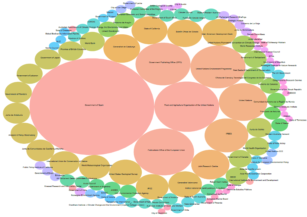
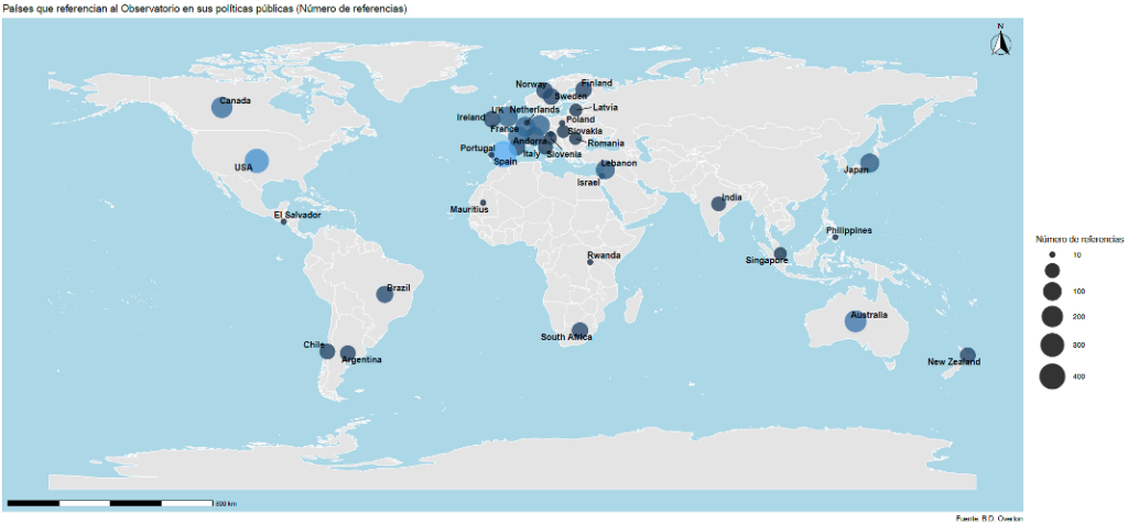
In 2024, the University of Granada published an institutional report on the influence of its research activities on public policies. This report includes references received in reports and documents from socio-political institutions (for example, the United Nations, the Intergovernmental Panel on Climate Change, the Organisation for Economic Co-operation and Development, the World Meteorological Organization, etc.). To this end, the Overton database was used, which compiles a wide range of policy documents worldwide. This same database was used to assess the impact of the Sierra Nevada Global Change Observatory on policies at regional, national and international levels. The database query was carried out in November 2024.
The Sierra Nevada Global Change Observatory has been referenced in a total of 37 countries worldwide by 116 different national and international public institutions (Figures 6 and 7). References to the Observatory are linked to all the United Nations Sustainable Development Goals, with greater incidence in Goal No. 11 “Sustainable Cities and Communities” and Goal No. 15 “Life on Land”. The public policy themes where the Observatory has been most influential are Environment and Nature, as well as Earth Sciences and Ecology.
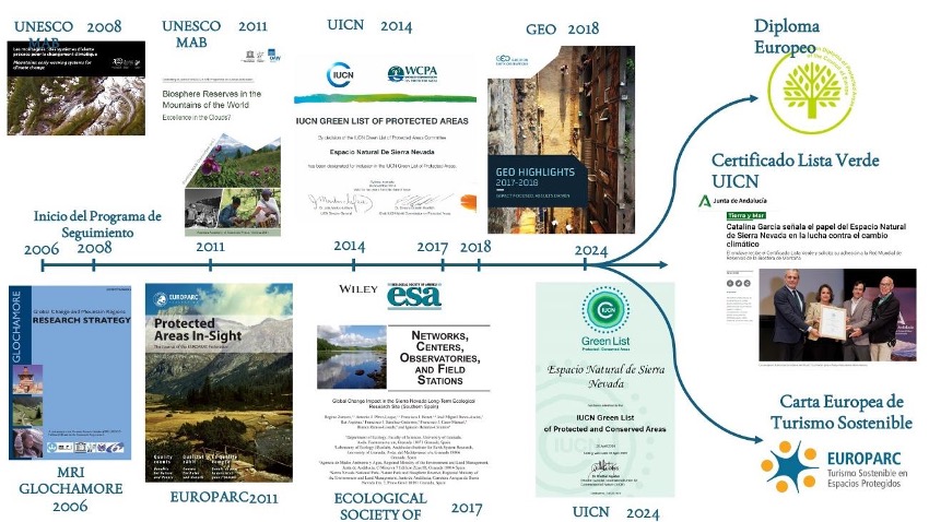
Thanks to the national and international impact of the work carried out, OBSNEV has been instrumental in the Sierra Nevada Natural Area being awarded major international recognitions, as shown in the diagram below:
3.16 Communication activities carried out at OBSNEV
The communication strategy has been designed to follow a transmedia format, in which all the products generated are linked by a central thematic axis and deployed across multiple media and platforms. In order to maximise dissemination impact, all products have been made available for free download or viewing, and in some cases also through widely distributed printed materials.
The number of visits recorded as of December 2025 for some of the different products developed is shown below:
- https://smartecomountains.lifewatch.dev/: between 20,000 and 25,000 visits
- https://obsnev.es: between 85,000 and 100,000 visits
- https://objetivosierranevada.es: approximately 20,000 visits, 2,000 unique users
- https://histonevada.obsnev.es: 12,000 visits
- https://climanevada.obsnev.es: 68,209,796 unique records (date, variable, station, value/measurement) downloaded
The main communication and outreach activities are:
3.16.1 Climate change: a global challenge. You decide!
A collaborative exhibition in which OBSNEV offers the community an innovative Shared Virtual Reality experience to explore the landscapes and ecosystems of Sierra Nevada from their formation to the present day. The exhibition space is complemented by other in-house communication products (infographics, videos, etc.).
Link: Exhibition at the Granada Science Park
3.16.2 Outreach infographic collection
A collection of infographics that provide compelling visual information about the context, objectives, and proposed solutions.
- Global change scenario in Sierra Nevada: Past, Present and Future
- Sierra Nevada lakes: natural laboratories to measure Global Change
- From field to web: Biological collections in the Global Information Network
- Forests of Sierra Nevada: evolution of Sierra Nevada vegetation and Global Change
- Atmospheric monitoring: high-technology sensors for the study of Global Change
3.16.3 Animated video collection
Educational animated videos have been produced to successfully reach all audiences.
- Sierra Nevada, a Global Change laboratory
- Sowing the future: local varieties
- Communal water governance
- Rivers of Life
3.16.4 Documentary podcast
Production of a documentary podcast entitled “The Value of the Mountain”. It consists of three episodes devoted to closely interrelated themes: water (Episode 1: The water that runs through my veins), crops and their varieties (Episode 2: You reap what you sow), and the ecosystem services provided by Sierra Nevada (Episode 3: Because I’m worth it). The three episodes can be listened to as a connected story or independently. Each episode is accompanied by three documentary videos offering the option of consuming the content as a visual report.
Link: Podcast: “The Value of the Mountain”
3.16.5 Illustrated album “Biodiversity Diary of Sierra Nevada”
Production of an illustrated album (digital and printed) on Biological Collections. This product functions as a field notebook, narrating the scientific workflow from the design of the sampling campaign to data collection, data digitisation and publication in cloud-based data repositories.
Link: Sierra Nevada Biodiversity Diary
3.16.6 Manuals and books on Sierra Nevada under global change scenarios
Development of a series of manuals and books aimed at explaining the functioning of Sierra Nevada ecosystems under global change scenarios. Both content and format have been carefully designed to make them attractive to non-specialist readers. These manuals and books are available on the Observatory’s website.
Link: Sierra Nevada Biodiversity DiaryPopular science books
3.16.7 Fold-out guide and plates for the identification of endemic flora of Sierra Nevada
Collection of illustrated botanical plates featuring endemic species of Sierra Nevada. This set of scientific illustrations has been produced both as a fold-out leaflet, in the style of a field guide, and as individual plates in the form of educational posters.
Link: Fold-out guide and plates for the identification of endemic species of Sierra Nevada
3.16.8 Illustrated cookbook “Garden and stew. Cooking and traditional varieties: intergenerational knowledge”
Publication (digital and printed) of an illustrated cookbook in which local plant varieties are the main focus. It represents an exercise in research and intergenerational knowledge transfer on crops and gastronomic traditions. A version of the cookbook has also been created in the form of an educational resource to be used in the classroom to work on the agrobiodiversity of Sierra Nevada.
Links:
- Illustrated cookbook “Garden and stew. Cooking and traditional varieties: intergenerational knowledge”
- Garden and stew in educational fact sheets
3.16.9 Photography contest “Objective Sierra Nevada”
The photography contest “Objective Sierra Nevada” was organised with the aim of promoting respect for nature and showcasing the beauty and uniqueness of life and landscapes in Sierra Nevada through highly captivating images.
Link: Objective Sierra Nevada
3.16.10 Exhibition at La Madraza (UGR) on the Sierra Nevada Global Change Observatory and its long-term ecological monitoring programme
Since 10 March 2025, the Palacio de La Madraza has hosted an exhibition dedicated to the Sierra Nevada Global Change Observatory. The exhibition was inaugurated by the Rector of the University of Granada, Pedro Mercado Pacheco, and the Director of the Sierra Nevada Natural Area, Francisco de Asís Muñoz. One of the main objectives of the Observatory is the transfer of scientific knowledge in a global change context, a task that increasingly requires a multidisciplinary approach. Likewise, the generation of long-term data series collected from diverse sources is another of the Observatory’s major achievements. To give maximum visibility to the information generated, applications in different thematic areas have been developed and are presented interactively in the exhibition.
Link: Exhibition at La Madraza (UGR) on OBSNEV
3.16.11 The Global Change Observatory and European research infrastructures
The Sierra Nevada Global Change Observatory (OBSNEV) maintains an active and strategic relationship with several European research infrastructures, both in the field of long-term ecological observation and in the mobilisation, standardisation and integration of environmental and biodiversity data, as well as in the development of virtual laboratories and the provision of services for researchers, managers and citizens. This linkage strengthens the international profile of the Observatory and positions Sierra Nevada as a European reference site for the study of global change in mountain ecosystems.
Collaboration with LifeWatch ERIC: Smart EcoMountains project Smart EcoMountains
OBSNEV has worked closely with LifeWatch ERIC through the Smart EcoMountains project, an initiative aimed at developing advanced digital services for the analysis, visualisation and interpretation of ecological data in mountain ecosystems.
Within the framework of this project, Sierra Nevada acts as a reference natural laboratory, integrating:
- data from climate and microclimate sensor networks,
- long-term ecological information,
- analysis tools based on European digital infrastructures.
From OBSNEV, it is emphasised that Smart EcoMountains makes it possible to connect field monitoring with e-science platforms, promoting data interoperability and the development of digital ecosystem services oriented towards research, environmental management and the general public. Likewise, the project reinforces the role of the University of Granada and OBSNEV as a thematic node of LifeWatch for mountain ecosystems, contributing to the deployment and validation of new technological solutions under real-world conditions.
Integration into eLTER / LTER and participation in the Data Mobilisation Project Data Mobilisation Project
OBSNEV is an active member of the LTER/eLTER network, aligning its ecological monitoring programme with European long-term research standards. This integration has been implemented particularly through the eLTER Data Mobilisation Project, whose objective is to make the data generated at major European research sites accessible, interoperable and reusable.
According to information published on the OBSNEV news channel, Sierra Nevada has participated in the following processes:
- metadata harmonisation,
- adaptation to the eLTER Standard Observations,
- publication of digital assets in the infrastructure’s Digital Asset Registry (DAR).
The report de Sierra Nevada incluido en el Data Mobilisation Project documenta varios datasets ya movilizados, entre los que destacan:
- Meteorological data (SOATM_027)
Time series of air temperature, relative humidity and precipitation from the ClimaNevadadatabase, fundamental for the analysis of climate change in high-mountain environments. - Soil microclimate data (SOHYD_168)
Continuous records of soil temperature and water content obtained through sensor networks deployed across different Sierra Nevada ecosystems. - Physico-chemical data from aquatic systems (SOHYD_004)
Long-term series on water temperature, pH and electrical conductivity in rivers and other aquatic systems, key for assessing ecological processes and responses to global change.
These datasets, already published or in advanced stages of publication in the eLTER Digital Asset Registry, consolidate Sierra Nevada as a fully integrated LTER site within the European infrastructure, strengthening the comparative and transnational dimension of the studies developed by OBSNEV.
Publication of biodiversity data in GBIF
OBSNEV has also made a significant contribution to the global biodiversity data infrastructure GBIF through the publication of datasets from Sierra Nevada in the national node GBIF.ES.
The process followed includes:
- digitisation of historical and current biodiversity data,
- their taxonomic and spatial validation,
- and publication in standardised, open-access formats.
Los datasets integrados en GBIF procedentes de Sierra Nevada abarcan, entre otros:
- flora and fauna records obtained from long-term monitoring programmes,
- species distribution data associated with altitudinal gradients,
- information derived from biological collections and citizen science projects.
The incorporation of these data into GBIF allows the information generated by OBSNEV to go beyond the regional level, being reused in national and international studies on biodiversity, climate change and conservation, and reinforces the Observatory’s commitment to open science principles and FAIR data.