Aims
The aim is to generate digital climate maps of high resolution, both spatially (100 m) and temporally (1 year) for the average annual precipitation variables, average temperature maximums and minimums throughout the entire Sierra Nevada.
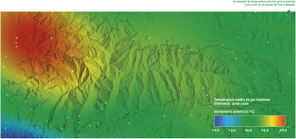
The maps represent the climate observed in the period 1961-2011, and the simulated climate according to the scenarios of climate change (A2 and B2) in the period 2011-2100.
Method and effort
The procedure for preparing climate maps of the past and future is the same, changing the starting data: data observed for the past and data simulated for the future.
As an initial step, a multiple-regression model was formulated taking the entry the data observed for the period 1990-2010 and predictive variables with a known influence on climate. The resulting equation is introduced in a GIS to generate a regression map, which is added to a map of spatially interpolated residuals, resulting in a reference map.
To calculate a climate map for the past or future of a variable and for any single year, the following steps are necessary:
- Selection of meteorological stations that have simulated data for this period.
- Calculation of the annual averages of the climatic variables for each station.
- Subtract from the annual averages and the reference map to find the anomaly values for each meteorological station.
- Spatial interpolation of the anomalies by regression tension splines.
- Adding together the reference map of the variable and the anomaly map of the period in question to create the final map.
Periodicity
The methodology is completely automated and it will be repeated as new climatic data improve those already available.
References
Ninyerola, M., Pons, M. y Roure, J.M. 2007. Monthly precipitation mapping of the Iberian Peninsula using spatial interpolation tools implemented in a Geographic Information System. 2007 Theor. Appl. Climatol.: 89. 195-209.